 |
|||||
|
|
|||||
|
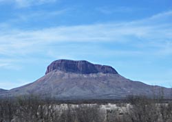
Scouting Chihuahua by Ed Buffaloe I was a bit skeptical when my friend Rob Lewis suggested we go to Chihuahua. I suppose I had imagined it to be an uninviting desert with few amenities and little culture. But when I began researching it, I became intrigued by the landscape of desert, mountains, and canyons--and by the culture, history, and prehistory of the area. When we finally went on our scouting expedition I was more than pleasantly surprised--we only had six days in country, but I fell in love with Chihuahua. The people of Chihuahua are industrious, prosperous, warm and friendly, and there is a whole lot more than desert in Chihuahua. Look at my photographs, and see what you think. This piece was intended to be a photo essay, but I felt I should offer some words of explanation, however inadequate. Click on any of the small images in this essay to see the entire sequence of photographs.
An excellent book for reading up on Chihuahua is the Northern Mexico Handbook by Joe Cummings. In fact, I’d say it is almost indispensible. We used it to find our hotels and to locate interesting places to visit everywhere we went. Another good book is National Parks of Northern Mexico by Richard D. Fisher, which contains useful historical and cultural information and some exceptional photographs. According to a correspondent, the name Chihuahua was given by the ancient inhabitants. The meaning is not known for certain, but two possibilities are “dry and sandy place,” and “place where two rivers meet.” Getting Across the Border
In the past, I had to pay my 210 peso entry fee on the spot, but this time I was told I could go to any bank and present my tourist form to pay the fee. This is a lot more trouble than simply paying the fee at the border, since banks in Mexico are always crowded and have limited hours. But I managed. In any case, the crossing formalities took about an hour. No one gets in a hurry in Mexico--we waited patiently while the man behind the counter ate his breakfast. We were on our way soon enough. Parral
Rob and I appeared to be the only gringos in town. Everywhere we went we were stared at as if we had come from another planet. We were stopped on the street by a fellow who tried very hard to communicate with us, but whom we could barely understand. He was trying to tell us something about Apaches. The Chiricahua Apache lived primarily in the Sierra Madre mountains of North Central Sonora, but often raided as far afield as Arizona, New Mexico and Chihuahua. Later, we speculated that perhaps he was trying to tell us he was a descendant of Apache Indians. I believe he wanted to be our guide and possibly show us Apache artifacts of some sort. Rob tried to explain to him that we were leaving the next morning. He seemed to want us to go with him immediately. We wandered around town a bit and took some photographs. Parral is a nice place, and I would like to go back when I have time to explore it more thoroughly. There is a mine tour that sounded interesting, a Francisco Villa museum, Villa’s grave, an interesting church or two, and I’d really like to follow up on the Apache connection, however tenuous. Parral is a large enough town that we found a 24-hour restaurant where we could have an early breakfast. Copper Canyon and Creel
Don’t let the map fool you. You might think it is only 80 or 100 miles from Parral to Creel, but the trip takes about six hours. The map gives no indication of the difficulty of the terrain--the mountains, canyons, and winding roads with switchbacks. The only town of any size between Parral and Creel is Guachochi (not shown on my map), and it is actually a few miles off the main road.
I really wanted go to the small town of Batopilas, because there is a “lost” cathedral there which I wanted very much to photograph. Unfortunately, the road to Batopilas is unpaved, and we felt Rob’s Toyota Echo might not be able to negotiate it. We did learn, however, that there is bus service from Creel to Batopilas, as well as private tours that will take you there and many other places as well. Creel is about 7,700 feet above sea level. A rail depot and logging town, it has become a major tourist destination by default. By virtue of its location, Creel is the primary staging point for expeditions into the canyon country. We positively hated the town. Our outlook may have been colored somewhat by the fact that the heat in our hotel was turned off at 8 PM, and the temperature fell below freezing that evening. We had tried several higher-end hotels, but they were full up. Lesson: if you plan to stay in Creel, make reservations in advance. Creel was colorful, but too much of a tourist trap for our taste. We got up before dawn and left. There was frost on everything. There is some beautiful country between Creel and Cuauhtémoc--mountains interspersed with high mesas--most of it farm and ranch country with many orchards. We had a late breakfast in Cuauhtémoc. Nuevo Casas Grandes and Paquimé
We were again pleasantly surprised when we discovered a cuota (toll road) that took us most of the way to Nuevo Casas Grandes. This reduced our travel time considerably and enabled us to reach our destination by 3 PM. Along the way we stopped briefly in Ricardo Flores Magón, a pretty little town named after the famous revolutionary figure.
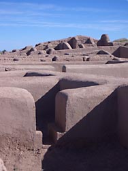
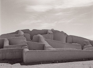
I probably flubbed a chance to get inside the ruins. I was shooting with a Pentax 645, which attracted the notice of a gentleman who asked me if I was a professional photographer. I told him no. He spoke good English and said he worked at the site. I should have jumped at the chance to ask if he could get me a closer look at the ruins, but it simply did not occur to me at the time. Rob suggested later that I might have been a bit more aggressive. After taking photographs, Rob and I toured the museum, which featured not only information about Paquimé but a travelling exhibit about China as well. A display in the museum stated that the
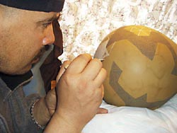
Paquimé culture was most closely related to the Mogollon culture, exemplified by the site at According to a local inhabitant of the area, when the Spaniards arrived in Chihuahua and discovered the ancient city abandoned and in ruins they asked the local Indians what its name was and they replied “Paquimé,” which means “I don’t know.” Mata Ortíz After leaving Paquimé we realized we still had time to go to Mata Ortíz, the local pottery center. According to Joe Cummings in The Northern Mexico Handbook, one Juan Quezada single-handedly revived the traditional Paquimé style pottery some 600 years after the decline of the Paquimé civilization. Now the entire town of Mata Ortíz is devoted to making pottery. Our map showed a dirt road from Casas Grandes Viejo to Mata Ortíz, but we found a relatively new paved two-lane highway. However, the streets of Mata Ortíz are dirt, and we arrived in the middle of a sandstorm which made it difficult to open the doors of our vehicle, let alone stroll around town in comfort. The lens I had on my camera got grit in it immediately and ceased to focus properly. I’ll be the first to tell you that I don’t know much about pottery. However, I’ve spent a lot of time in New Mexico and seen the fine Navajo and Hopi pottery made there. I’ve also seen the prices fetched by the work of certain well-known potters. I believe if you bought pottery made in Mata Ortíz and took it to Santa Fe you could simply add a zero to the end of the price and sell it readily.
I would have walked through Mata Ortíz and taken photographs had it not been for the sandstorm that was raging. But Rob and I were satisfied with our little expedition and decided not to tarry. On the way in I had seen a sign pointing off into the mountains that said “La Cueva de Ollas,” and at Señor Quezada’s place I had seen a photograph of the interior of the cave and decided I wanted to go there. In the event, after driving for 11 miles, we found the dirt road too difficult for Rob’s small vehicle, but I determined to return as soon as possible. The map shows a string of Native American sites stretching for more than a hundred kilometers from Casas Grandes south to Madera. Future Plans I have no doubt I will return many times to Chihuahua. I want to spend days and weeks in some of the places we simply passed through on this trip. Copper Canyon is near the top of my list, as is the entire area south of Casas Grandes. |
|||||||||||||||||||


|
|
|
|